Friends - Thanks for your patience during my absence. Last week, I was off doing this:
That very small dot is the old geographic marker for this:
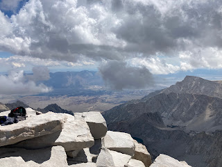
Yup. Over a 7.5 day period, the Outdoorsman and I hike approximately 83.5 miles/134 km and experienced around 17,300 feet/5,273 meters of vertical ascent - and as part of that hike, we ascended (and descended) Mt. Whitney, 14,505 feet above sea level (4,221 meters), the highest peak in the contiguous U.S. (otherwise known and the lower 48 states).
The hike went well. Overall my training program seemed to be a success: I managed to complete every day's hike (with almost nothing left, but I did make it) and got up Mt. Whitney (the altitude was a challenge; the ascension is a story in itself). I arrived back at The Ranch late Saturday night; other than being tired and a bit sore, I was in surprisingly good condition.
Thanks for your patience. I am super excited to share my journey with you.

.JPG)


Congratulations are definitely in order! That's a fantastic accomplishment. And I love the location reveal in the final post of the series. Glorious photos. I love blog reading for things like this.
ReplyDeleteThank you Leigh! I am happy because it was a goal I set for myself and achieved (and ironically, the last post is really the first post!).
DeleteSo much natural beauty. Every single day.
That sounds like an achievement, congratulations on your successful endeavor, That is a great story to be able to tell others.
ReplyDeleteThank you very much! I try not to brag about much, but this one is definitely going into conversations.
DeleteThanks for sharing the visuals TB, 83 plus miles........I'm tired just reading that. Height with the accompanying less oxygen does make it noticeable, eh?
ReplyDeleteIt does, Nylon12. Reaching the summit of Mt. Whitney was a struggle. Already thinking about how to do better next year.
DeleteWow! Congratulations, TB. Praise God for keeping you both safe.
ReplyDeleteGorgeous creation you share with us. Thank you.
You all be safe and God bless.
Thank you Linda! He did indeed keep me safe, although sometimes I tried very hard to counteract Him!
DeleteMan, well done. I can only do that vicariously now. Thanks for the view.
ReplyDeleteYou are welcome sir! Glad I can share.
DeleteThat is super awesome. Super awesome being so far beyond regular awesome that some form of log scale must be used.
ReplyDeleteI was worried when I looked up the ascent numbers and I understand you when you said you did it with not much left in the tank at all.
The last photo with the shadows on the mountains is beautiful and my hindbrain woke up, poked me and started yelling, "It looks like an Albert Bierstadt painting!"
You have both a great accomplishment and great memories.
Thank you for sharing and I'm looking forward to more.
Thank you John. To be fair, I suspect this is about as much mountain as I ever need to climb (no Denali or Everest for me).
DeleteHonestly, the ascent in terms of the physical path was pretty well put together and relatively safe - there was never a time that I felt like I was going to fall off. The challenge became the altitude and just the overall length of the hike - fortunately I was in a group and we all made it.
I did not remember Albert Bierstadt - but when I looked him up, I totally remembered his paintings (or at least one). I will definitely see if I can find some views I recognize.
Congratulations on the achievement! I think the highest I've been is in the mid 13,000's on some of the higher peaks in the Wind River Mountains of Wyoming.
ReplyDeleteThank you Ed! My previous high point was 11,000 feet, but we went over that regularly during this hike with at least two mountain passes at 12,000 feet, plus a great deal of time spent between 10,000 and 11,000 feet.
Delete