Rising the next morning, I definitely felt more like myself: better mood, more energetic, and I had an appetite. Which was great - because today was another day of ascending.
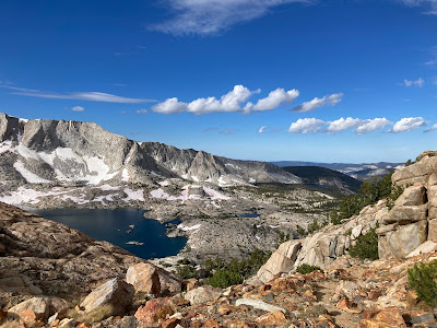
Our ascent (after breakfast and packing up) took us further up towards Mt. Goddard. We passed by Hell for Sure Lake, which was our original destination until my untimely health incident. It was relatively straightforward enough now, but I did tell The Commissioner there was no way I could have made it last night.
It really was a very serene lake.
From here, we continued until we were on our way up the Hell for Sure pass - names, as it turned out, from shepherds coming up the others side of the pass (from where we were) and commenting it was "hell for sure". Not quite the story you want to hear as you continue up, although ours was arguably the easier ascent.
Oddly enough given the previous day's outcome, I do not remember the ascent being particularly taxing beyond the general fact we were going up.
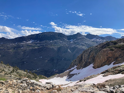
For all of the "going up-ness", I have to admit that I have come to love passes in general. The sense of reaching a point and suddenly whole new vistas opening up is amazing and never gets old. Who knows what lurks beyond the top as you come up to it?
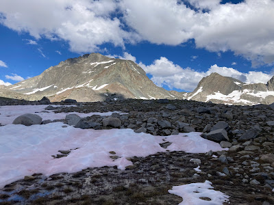
Yes, that is snow. It was the first time we encountered it, but not the last.
Once you come up of course, you have to head down. And for me, descending is actually the more difficult task (I get the impression many of my fellow hikers felt that way). Ascending is mostly just brute endurance and pulling one's self up; descending is going down over uneven surfaces or taking larger drops from one level to another than one typically does. It is hard on the knees and the risk of turning an ankle or a mis-step that creates a knee injury is much higher. I always, inevitable slow down on the descent.
Our descent took us to down to where we met the south fork of San Joaquin River, which runs 366 miles total - although not nearly the size and scope of the river that it achieves much lower in the Central Valley.
By the time we hit the river for our lunch break, it was clear that my Altitude Sickness of the previous day had returned. Yes, I felt slightly better than the previous day and yes, I had a bit more of an appetite - I had carrot sticks and a tortilla - but the lack of energy, upset stomach, and general feeling of unease had returned (although, thankfully, no throwing up this time).
I was helpfully stripped of most of my items (but retained my pack this time) and started my 50 step ascent up the valley.
We covered a total of 9 miles that day; I cannot with any clarity tell you precisely how many of those miles were covered after lunch. Not 50% I am sure, but maybe 40%? It does not really matter in that sense of course; much like the previous day I kept my head down, counting out 50 step intervals. I did get a chance to look up more (thus more pictures) and the merry sound of the river did make for a better companion than my own misery.
The last part of the ascent consisted of about a half mile of a semi-steep rise up granite. The Commissioner forewarned us that we would see essentially hit two false "tops" before we reached the final one. I appreciate that sort of information; there is nothing more depressing than reaching what you think is the top only to find there is more to go.
I easily took an hour or more to cover what took everyone else 20 to 30 minutes.
By the time I arrived at Martha Lake and the base of Mt. Goddard (pictured below), I was completely beat.
Someone had set my tent to the side and this time I put the tent up myself. It was very slow; I did not time myself but it easily felt that what should have taken 15 minutes took 45 or more minutes. Much like climbing, putting up the tent was a series of short bursts of activity followed by active rest; getting up and down was especially taxing.
Taxing or not, of course, I got the tent up.
Upon getting the tent up, I immediately crawled into it and my sleeping bag and again had a series of fitful naps and waking events. Again, The Commissioner made sure that I got soup down and had water available and told me that my one job was to rest.
It was an assignment I was again grateful to receive.


Excellent job on the photos what with your being under the weather again. Bit of luck to hit that pass in sunny conditions, gorgeous views there TB. Thanks for sharing all of them.
ReplyDeleteNylon12- The picture thing is almost instinctive now and (to be honest) to some extent I do it so I will have them to share and post.
DeleteAlthough we had rain at some point most of the days, the weather really was pretty spectacular. And the temperature was great: mid-40's at night, mid-60's during the day. You could not ask for better hiking weather.
"Who knows what lurks beyond the top as you come up to it?" I remember that, and it was one of my greatest motivations to keep going; a reward, so to speak.
ReplyDelete"And for me, descending is actually the more difficult task (I get the impression many of my fellow hikers felt that way)." I remember that too. Even if all goes well, it's a tremendous strain on the knees.
I'm so sorry, though, that you were sick. That's a joy killer for sure. But you made it, the photos are spectacular, and hopefully your long-term memories will make up for the experience of the discomfort.
Leigh, I do not think I would have had my sentiment about passes when I first started hiking, but having that pay off at the end really makes it worth it. It also is one of the few hiking activities where there is a direct payoff (I climb, I get a view).
DeleteDescending - My knees do not suffer quite as much as The Outdoorman's, although to be fair I am very careful about that part of it. My larger risk is turning my ankle, which seems to almost happen with alarming frequency.
The sickness was definitely a pall on those days. Perhaps it did help me appreciate the scenery that I did see more. And I certainly learned a bit about my ability to press on and through things.
For sure, give me a steep pass to hike up any day of the descent from the same steep pass. Gasping for air is much easier than fighting sore knees, calves, thighs and blistering feet.
ReplyDeleteIt is a shame that you have to fight altitude sickness, at least two of the days out there but as you say, at least "you didn't die."
Ed, it seems counter-intuitive unless you have actually hike it, but having almost twisted my ankles several times, the risk is much greater.
DeleteIt would make for an interesting hike to go back someday and redo it and see the parts that I effectively glossed over. If my few pictures are any indication, it was beautiful country.
But, any day you do not die is still a good day.
As you and Leigh said, downhills are tough on my knees. When I finally learned the rudiments of topo maps, I can use the date to go steeply uphill and more gradually downhill.
ReplyDeleteI was being chided by an Army coworker for my total lack of topo skills.
I reminded him that in the Navy, topographical changes equate to running aground and we try to avoid that.
It's a dichotomy that sleeping outdoors under cover can be relaxing and at the same time, in tents. (Snort)
From my elevation in Philly of 90 feet, your altitude is waaay up there.
Concur with what all the comments said.
John - Great point on the fact that different groups use maps for different reasons!
DeleteOne common complaint I have (and most of my co-hikers) is that one never sleeps "soundly" when hiking. I feel like I wake up multiple times during the night. I fear it is a feature, not a bug.
New Home is also pretty flat land. One of the things such trips remind me of is how much I enjoy mountains.
And you made it all under your own power. With an Angel watching over you, I am sure.
ReplyDeleteThank you for further pictures of God's creation, TB.
You all be safe and God bless.
Linda, I suspect multiple angels were involved. I fear I am a bit of a basket case.
DeleteAnd you are more than welcome. It is a pleasure to share them.
Breathtaking pictures again, TB. So sorry to read the sickness struck again.
ReplyDeleteKings Canyon is very lovely (we were there last year as well for the Mt. Whitney hike).
DeleteInterestingly there is not a "time frame" around altitude sickness. The time I had it in 2022 I recovered after one day; likely if I had done nothing at all on Day 3 I would have recovered sooner - but we had a schedule to keep.